


Montaña amarillo

nave
User
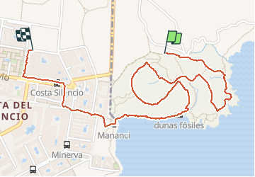

Length
3.7 km

Max alt
57 m

Uphill gradient
78 m
Km-Effort
4.8 km

Min alt
0 m

Downhill gradient
93 m
Boucle
No
Creation date :
2021-05-05 16:16:50.411
Updated on :
2021-05-05 17:39:29.699
1h07
Difficulty : Very easy

FREE GPS app for hiking
 SityTrail
IGN / Geographical institutes
SityTrail Plus
The world is yours!
About
Trail Walking of 3.7 km to be discovered at Canary Islands, Santa Cruz de Tenerife, San Miguel de Abona. This trail is proposed by nave.
Description
Tour du volcan
Positioning
Country:
Spain
Region :
Canary Islands
Department/Province :
Santa Cruz de Tenerife
Municipality :
San Miguel de Abona
Location:
Unknown
Start:(Dec)
Start:(UTM)
339174 ; 3099695 (28R) N.
Comments